Developer Blogs
A Path to Success: Maps, and their Making
As our game testers play The Old Republic™ and we track their characters, they produce a lot of data - on everything from how long it takes them to move across a planet, to where they stop and look at the scenery. We bundle all this data together into what we call ‘metrics’.
Our design team loves metrics.
We love them because when designing a game, it’s one thing to say how things should be, but it’s quite another to see how things actually are. When we see metrics, we see exactly how the game is being played in pure numerical form. Getting this level of insight into what you’ve designed is often vindicating, invigorating and sometimes even humbling. Of course it can also be panic-inducing at times, too!
Let me give you an example. Some time ago, resident metrics enthusiast (and Lead Combat Designer) Georg Zoeller posed a simple question to the design team: “Which part of the user interface is opened more than any other when playing Star Wars™: The Old Republic™?” It was a simple question, but the answer wasn’t any of the UI parts you might expect: not our character sheet, inventory or the Crew Skills window. No, the winner was the World Map. And it won easily - by more than an order of magnitude. Let me tell you why.
Galactic cartography
Having good navigation is important for any game, but particularly so in any massively multiplayer game, where wanderlust is positively encouraged. For The Old Republic, we realized that we had some relatively unique problems early on.
First off, once your character leaves their Origin World, other planets tend to be significantly larger in terms of land mass than those you might find in other MMOs – sometimes five or six times as large. While this is really cool for creating canonically expansive worlds in the Star Wars™ universe like Hoth or Tatooine, it also creates interesting design considerations. As the player is only adventuring in perhaps one-sixth of the map at any given time, having one world map would result in everything he cares about at a given time being compressed into a tiny corner of the map, making that map pretty much unusable.
The second problem is that Star Wars is a science fiction setting (well, perhaps science fantasy) at heart. As a result of this, a great deal of our content happens inside - inside buildings, compounds, space ships, space stations and so on. Nowhere is this truer than on the city worlds of Nar Shaddaa and Corellia which, from a map sense, are closer to a dungeon you might find in another MMO, than an open world zone. We decided fairly early on that we needed to find a map solution that would do indoor areas well.
The third issue is that our worlds and content flow were still in a lot of flux at the time that we needed maps. As we experimented with marrying BioWare-style content with MMO-style freedom and zones, we were frequently expanding and shrinking planets, adjusting flow, adding and removing missions and adventure areas… all of this happened as we got better feedback, and a better sense of what worked for our gameplay style. This created a unique problem for our maps – being sure that players could navigate to their mission objectives was hugely important for us to validate our content and planet design flow. Practically, we could not wait for our artists to hand-paint maps every time the world builders made changes.
Making a map - automatically
What we decided to do was to have a design process which generates maps based on the objects that exist inside of any zone in the game world. To start off, a designer draws a trigger box around part of the world, and then designates which map that trigger box belongs to. He then uses a tool which effectively renders only the objects that are inside of that particular trigger box. This gives us a basic map image. After this, he runs a Photoshop tool which applies a filter that makes the resulting image look techy, holographic and vaguely architectural (if indoors) or topographical (if outdoors). Finally, an artist does a cleanup pass, removing visual artifacts and other noise that might have crept into the process.
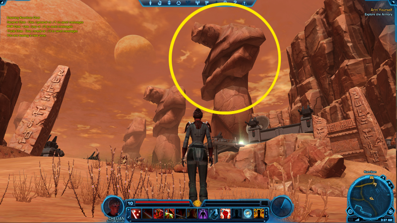
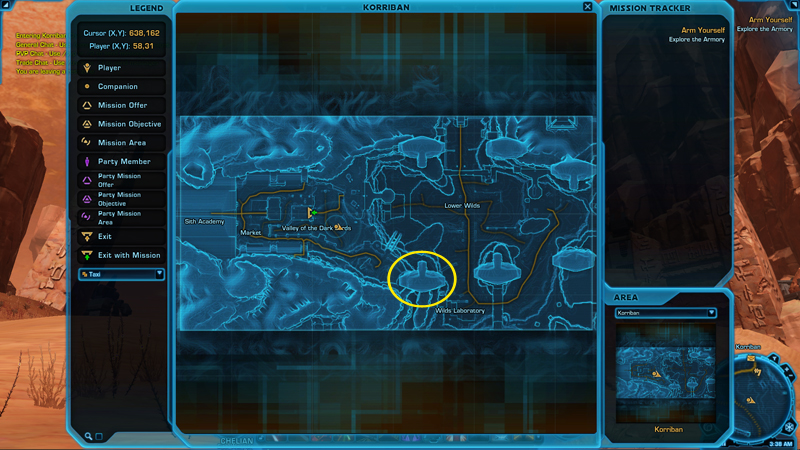
The end result is that we have maps that can show astonishing details about the game world. Chairs, crates, statues – all manner of items show up on the map from a birds-eye view, giving the player a real sense of where they are in the world. The resulting map was in fact so good that early on, we found unexpected obstacles were appearing on the map. After investigation, it turned out they were chandeliers and rafters rendered near the ceiling.
Click the above image for a larger view.
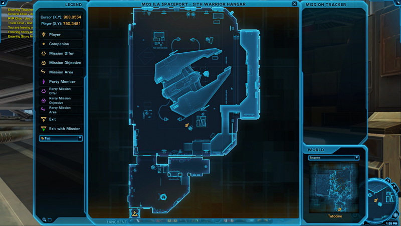
A map of the Sith Warrior’s ship in his hangar on Tatooine. The map process picks up most of the detail of the zone and automatically renders it to the map – as an example, you can see that my character is standing next to a forklift.
This mapmaking process is repeated dozens of times per planet. Each planet has a master world map, a handful of smaller hub maps that more closely approximate an adventuring zone, and dozens of interior maps (pretty much any building with more than one room gets its own map). The resulting workflow is more complex than I had imagined when we started the process, but not impossible. One full-time map designer does most of the work, and near the end of our development milestones when the world builders all finish up their deliverables, we give him a little help to be sure all the new areas get maps that are usable and polished.
The final product is a map that looks very slick, but is still relatively easy for designers to keep accurate. For example, when the artists move or change the objects placed in a world after the initial map volumes are placed, we can use the process to quickly adjust those volumes and regenerate the map.
 |
 |
Click the above images for a larger view.
Another example of the level of detail captured by the map making process.
Maps with a Mission
Of course, the look and feel of maps is really only a small part of their usability – what is far more important is the information that is shown on the map, and whether or not the player can find what they’re looking for. That task is handled by icons we put on the map. The obvious suspects are there: icons for trainers, mailboxes, galactic marketplace terminals, etc.
What most players are looking for on their map are missions. We want to ensure players can find all of the cool stuff that our worldbuilders put into the world, so every mission has one or more icons on the map that show you where to go. Moving your mouse over an icon shows you which mission is satisfied in that area, your progress in that mission, and a rough area where mission objectives can be found.
I know some people like hunting far and wide in a zone to find an objective, or reading between the lines in obscure mission descriptions to find their goal. However, from our point of view, we wanted to be sure that players were spending time on missions doing fun stuff. Getting missions and completing them in The Old Republic is uniquely fun due to our conversation system, the cinematics you’ll take part in and, of course, the story itself. Going to a mission location and laying waste to your enemies is also fun. By contrast, hunting for one clickable object in a large 3D space is typically not fun, nor is travelling through all of Tatooine (which is, again, several times the size of other typical MMO zones) trying to find which of the many Sandpeople tribes is headed by Bob, the Mission Objective.

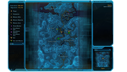
Click the above image for a larger view.
On this map of Tython, you can see mission icons for the two missions I’m on, and one icon showing a mission offer. The circle represents a mission icon that I’ve moved the mouse over, offering me a better idea of the hunting radius, as well as what I’m hunting, in a given area.
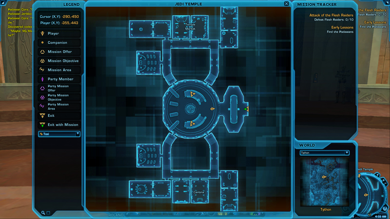
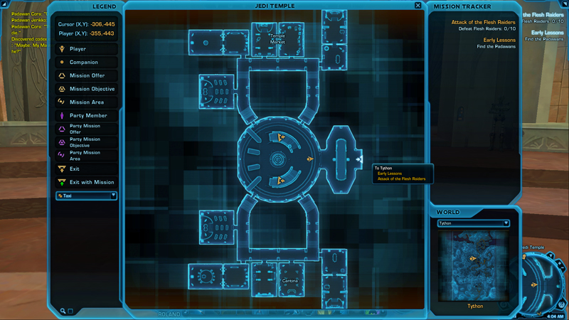
Leaving a breadcrumb trail
Of course, all of this is complicated by the fact that our planets have dozens and dozens of maps. Having map markers showing where your mission objectives are in the wilds of Tython isn’t incredibly helpful if, for example, you’re inside. This is, again, much more problematic on the city worlds, which have huge numbers of interiors.
In order to combat this problem, we introduced a system we call ‘breadcrumbing’. This system allows the designer to specify which map ‘owns’ a mission. If a mission in your mission log is on your planet but not on your map, it will highlight an exit to that map, telling the player which way to go to get to the ‘right’ map. Moving your mouse over the exit will tell the player which missions are to be found in that direction.
 |
 |
Click the above images for a larger view.
A map of the Jedi Temple on Tython. The green icon shows you there are quests outside - mousing over the icon shows you which ones. (A colorblind-friendly version of the iconography is being worked on.)
This system started out very simple, but over time has become more powerful in order to deal with the intricate content and complex worlds that we wanted to create. For example, if a mission objective is on your map, but requires you to go through a tunnel to get there, the breadcrumbing system will intelligently lead you through that tunnel.
Like many games, we have shuttles and taxis designed to help you traverse the world quicker – a fact you’ll be abundantly thankful for when traversing the massive expanses of Hoth and Tatooine. On some planets, such as Coruscant and Korriban, there are areas that can only be reached via these travel mechanisms. Fear not, the breadcrumb system handles that, too.
 |
 |
Click the above images for a larger view.
If you have to take a taxi to get to a mission objective, the breadcrumb system will tell you which path to choose.
Maps for all
As we develop almost any system in the game, we ask ourselves if there are opportunities to add improvements to that system in order to make better group and social gameplay. As we were developing the map and breadcrumb systems, we realized we had a prime opportunity to make grouping and running missions with other players easier and more fun in The Old Republic with one simple addition: we show your group members’ mission icons too.
If other players in your group have the same mission you do, their name will be listed in the mouseover text for the mission icon or breadcrumb. If they have the mission and you do not, the icon will be purple. Mousing over the icons will give you more information about what your party member is trying to accomplish.
This simple feature makes it much easier to group with other players. Players can compare their missions, figure out which missions should be shared, and easily optimize a path that allows both players to accomplish their goals while out adventuring.

Click the above image for a larger view.
This map shows that my party member has three missions on Tython I don’t have – two on this map, and one following the moused-over breadcrumb into the Jedi Temple.
Showing the Way
In general, throwing maps into an MMO is easy. On the other hand, making maps that are comprehensive, accurate and useful to the player is much harder than you might imagine. Luckily for us, it was an area that we realized was hugely important very early on.
When Georg told the design team that maps were the most-opened part of the user interface in the game, our map specialists just nodded in understanding. They already knew that being able to find your way around the world was going to be hugely important to our success. Thanks largely to the enduring efforts of those on the map team who believe passionately in the importance of what they are doing, our maps system are a core, essential part of the adventuring experience in Star Wars: The Old Republic.
Click the above image for a larger view.
Bonus feature: The map goes semi-transparent once you start moving, so you can keep it up to navigate as necessary.
Damion Schubert
Principal Lead Systems Designer


You are about to leave this website...
This page is not meant to keep you from following the link you've clicked on. It is just a warning that you are about to leave this website. To go to this page, click the link below.
If you do not wish to follow this link, simply close this message.
The statements and opinions expressed on these websites are solely those of their respective authors and do not necessarily reflect the views, nor are they endorsed by Broadsword, LucasArts, and its licensors do not guarantee the accuracy of, and are in no way responsible for any content on these websites, and the Star Wars: The Old Republic privacy policy does not apply to their information collection practices.
Multimedia Player
Optional Cookies, including those that support the Multimedia Player, are currently disabled based on Your Privacy Choices settings.
Choose Accept and Play Video to enable the Multimedia Player, including its associated Cookies. This may involve the collection and sharing of your viewing information by YouTube for analytics and advertising purposes.
You can also choose to watch the video on YouTube.